


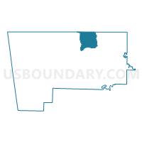
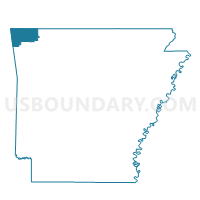
Voting District 069, Benton County, Arkansas
About
Outline

Summary
| Unique Area Identifier | 525939 |
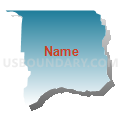
| Name | Voting District 069 |
| County | Benton County |
| State | Arkansas |
| Area (square miles) | 30.93 |
| Land Area (square miles) | 30.93 |
| Water Area (square miles) | 0.01 |
| % of Land Area | 99.98 |
| % of Water Area | 0.02 |
| Latitude of the Internal Point | 36.45824640 |
| Longtitude of the Internal Point | -94.11147230 |
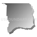
Maps

Graphs
Select a template below for downloading or customizing gragh for Voting District 069, Benton County, Arkansas


Neighbors
Neighoring Voting District (by Name) Neighboring Voting District on the Map
- Voting District 028, Benton County, AR
- Voting District 030, Benton County, AR
- Voting District 031, Benton County, AR
- Voting District 066, Benton County, AR
- Voting District 068, Benton County, AR
- Voting District 071, Benton County, AR
- Voting District 074, Benton County, AR
- Mountain Voting District, McDonald County, MO
- Seligman Voting District, Barry County, MO
Top 10 Neighboring County Subdivision (by Population) Neighboring County Subdivision on the Map
- Township 7, Benton County, AR (20,317)
- Township 6, Benton County, AR (14,033)
- Township 1, Benton County, AR (13,223)
- Mountain township, McDonald County, MO (1,382)
- Ash township, Barry County, MO (948)
Top 10 Neighboring Place (by Population) Neighboring Place on the Map
Top 10 Neighboring Unified School District (by Population) Neighboring Unified School District on the Map
- Rogers Public Schools, AR (81,256)
- Bentonville Public Schools, AR (74,655)
- McDonald County R-I School District, MO (18,808)
- Pea Ridge School District, AR (7,990)
- Southwest R-V School District, MO (4,746)
Top 10 Neighboring State Legislative District Lower Chamber (by Population) Neighboring State Legislative District Lower Chamber on the Map
- State House District 98, AR (40,678)
- State House District 131, MO (36,451)
- State House District 68, MO (35,930)
- State House District 95, AR (33,192)
Top 10 Neighboring State Legislative District Upper Chamber (by Population) Neighboring State Legislative District Upper Chamber on the Map
Top 10 Neighboring 111th Congressional District (by Population) Neighboring 111th Congressional District on the Map
Top 10 Neighboring Census Tract (by Population) Neighboring Census Tract on the Map
- Census Tract 701, McDonald County, MO (6,194)
- Census Tract 201.01, Benton County, AR (5,952)
- Census Tract 201.02, Benton County, AR (5,647)
- Census Tract 207.01, Benton County, AR (4,985)
- Census Tract 207.03, Benton County, AR (4,581)
- Census Tract 9604.01, Barry County, MO (4,190)
- Census Tract 207.04, Benton County, AR (3,934)
- Census Tract 214.04, Benton County, AR (3,476)
Top 10 Neighboring 5-Digit ZIP Code Tabulation Area (by Population) Neighboring 5-Digit ZIP Code Tabulation Area on the Map
- 72712, AR (40,933)
- 72756, AR (38,455)
- 72714, AR (11,880)
- 72751, AR (6,434)
- 72732, AR (4,716)
- 64856, MO (4,251)
- 65745, MO (2,693)